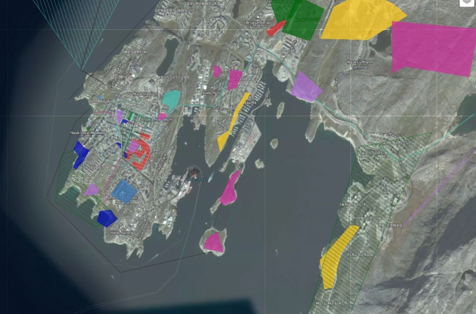
Alternative future for Nuuk, Greenland
Nuuk is Greenland's capital and largest city, serving as its governmental, economic, and cultural hub. Home to 19,872 people, with nearly 90% of its residents being Inuit, it's considered the world's most indigenous city. Today, rapid Growth Pressures reflect Nuuk's growing pains as it transitions from a small Arctic capital to an increasingly connected international hub. Nuuk is experiencing rapid expansion and continues to grapple with the legacy of colonialism. In addition to the housing crisis, tourism surge has put additional pressure on infrastructure that was already strained. Educating the local population is vital to protecting the area's cultural heritage rooted in its agricultural
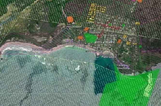
Alternative future for Isabela Island, Galápagos
Isabela Island is home to a diverse range of ecosystems. Isabela Island faces a number of conservation and human-related challenges. These include the impact of invasive species, threats to endangered species like the mangrove finch, flamingos and pink land iguana, and the need for sustainable fishing practices and human settlements. The balance between human needs and conservation efforts is a constant challenge, with illegal activities like tortoise poaching and overfishing still occurring. In terms of community engagement, educating the local population about the importance of conservation and involving them in protection efforts is crucial.

Alternative future for Santa Cruz Island, Galápagos
Santa Cruz faces is vulnerable to the effects of climate change, including the risk of natural disasters, including more frequent and intense storms, rising sea levels, floods, landslides, earthquakes, and storms, requiring ongoing efforts for disaster preparedness and recovery in addition to high housing costs, traffic congestion, issues related to business development, such as navigating regulations and rising costs, and faces ongoing challenges related to substance use among youth. In terms of community engagement, educating the local population about the importance of conservation and involving them in protection efforts is crucial.
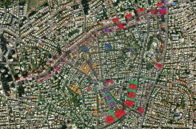
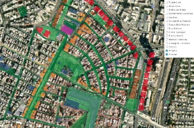
Alternative future for Ramat Gan
Ramat Gan's city center is surrounded by major traffic and commercial corridors that enclose a dense urban core. The neighborhood features older buildings originally designed as basic housing solutions. Despite their modest quality, rising prices and strong demand indicate the area's desirability. Expected demographic growth will intensify existing housing pressures and infrastructure strain. This project employs participatory planning strategies to address these challenges. By centering residents' voices, the workshop develops collaborative solutions for key issues including housing density, urban heat island mitigation, and public health to guide future neighborhood planning efforts.

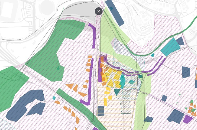
Alternative future for Talpiot East ("Talpaz"), Jerusalem
Walking is the healthiest, most natural, environmentally friendly, and egal-itarian way of moving in space, and it plays an important role in urban life. But winding routes in Talpaz, that was established on land captured in the Six-Day War and occupied since then, lengthen the distance between junctions, reducing connectivity and walkability. The goal of this study is to examine whether and how digital plan-ning practices can be implemented to promote walkability in a hilly neighborhood. The findings indicate that walkability prin-ciples can be integrated into planning for hilly terrain, despite the challenging circumstances.
Alternative future for Ezrat Torah, Jerusalem
Ezrat Torah was established and populated over a long period as a result of many individual decisions. Before the 1967 war, Ezrat Torah lay on the Jordanian border. After the war its relative location changed from frontier settlement to inner-city neighbourhood. From 1995, Ezrat Torah gradually changed from a mixed neighbourhood housing secular, religious and ultra-orthodox residents to a pure ultra-orthodox neighbourhood, and from an area that used to be populated by native-born residents to one that housed 25% foreign-born residents. The goal of this workshop is to propose a new urban future for Ezrat Torah with significant community involvement.
Alternative future for Beit Safafa, Jerusalem
This study advances previous theoretical approaches by integrating local knowledge with big data to envision an urban future for Beit Safafa, a Muslim neighborhood in Jerusalem. Data collection was conducted through a planning workshop that brought together residents, representatives from the Jerusalem Municipality and Ministry of Environment, and students. The findings demonstrate that strategically combining diverse knowledge sources through digital processes enables holistic planning that integrates all urban systems. Local knowledge serves as a crucial mediator at the intersections between various systems, creating cohesive and seamless urban space. This approach achieves both democratic participation in the planning process and an optimal planning outcome responsive to residents' needs.

Alternative future for Sharafat
This workshop integrates local knowledge with big data to envision an urban future for Sharafat, an Arab-Muslim village that came under Israeli jurisdiction after the 1967 War. The planning workshop brought together residents, municipal and environmental officials, and students. Through digital processes, participants analyzed the effects of different policies and projects across multiple scenarios. Comparing these scenarios revealed common solutions, including connecting Sharafat to neighboring Beit Safafa via a highway overpass and increasing building rights at strategic locations. This approach achieves both democratic participation and planning outcomes responsive to residents' needs.
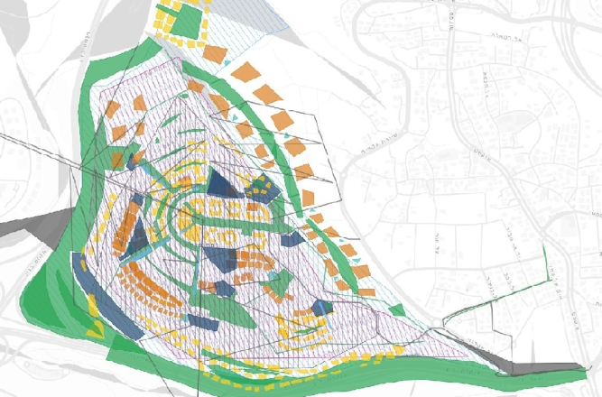
Alternative future for Ramat Shlomo, Jerusalem
Ramat Shlomo is a peripheral neighborhood planned and built in the mid-1990s primarily for the Haredi community on land captured during the Six-Day War. The neighborhood offered families an opportunity to transition from small, expensive apartments in Jerusalem's inner city to more spacious housing, though at the cost of reduced accessibility to the city center. Population composition was coordinated through Haredi housing committees, whose allocation decisions reflected the proportional representation of different communities within the city. This workshop aims to propose a new urban future for Ramat Shlomo through meaningful community engagement and participation.

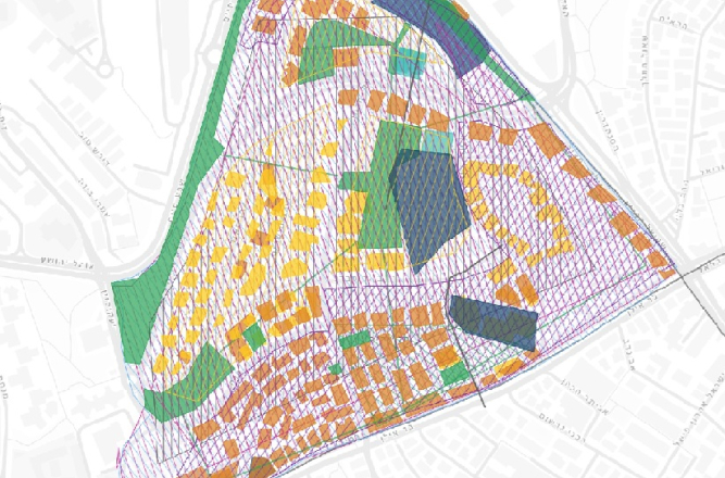
Alternative future for Talpiot, Jerusalem
In the 1920s, Bauhaus architect Richard Kauffmann designed Talpiot as a garden suburb under the British Mandate. Between 1968 and 2021, the neighborhood experienced significant population shifts, and piecemeal development has gradually eroded its original character. The main trends include increasing housing density, growing demographic diversity, and substantial population rejuvenation. To balance heritage conservation with development pressures and respond to evolving community needs, our workshop proposes an alternative future for the neighbourhood.
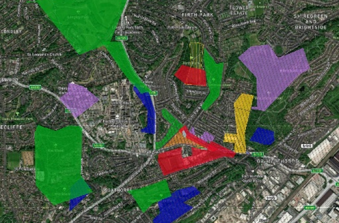
Alternative future for Page Hall, Sheffield
Page Hall ranks among Sheffield's most economically disadvantaged neighborhoods, with limited educational opportunities and high unemployment. The area is home to a diverse population of White British residents, Pakistani families, and Roma communities. These demographic shifts have created challenges around integration, economic deprivation, and inter-community relations. The neighborhood's history adds further complexity: Page Hall was previously slated for demolition under urban renewal schemes before becoming a Roma settlement hub. This workshop is motivated by the need to center residents' voices in the urban renewal process.
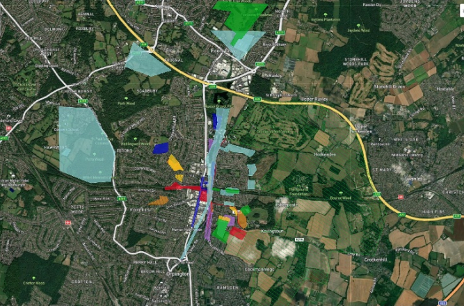
Alternative future for St Mary Cray, London
For many generations, the Romani community has been woven into the fabric of the Cray Valley, forming what has been characterized as "a hidden minority" with centuries-deep roots in Britain. Today, St Mary Cray is home to one of the United Kingdom's most substantial settled Romani populations. In terms of community engagement, it is vital to educate the local population about inclusion while also protecting their rich heritage deeply rooted in the area's agricultural history and cultural landscape. Additional context includes the beginning of gentrification processes in St Mary Cray's under urban renewal schemes motivated us to making residents' voices heard.

Alternative future for Cejl neighbourhood, Brno
In a Czech context, the creation of slums was spurred both by gentrification and slumification, whereby the economic transformation after the fall of state socialism played a formative role. The Cejl neighbourhood is considered to be socially excluded localitie (SEL) – a term used in Czechia to refer to disadvantaged neighbourhoods, characterized by the segregation of poor Roma and substandard housing - within Zábrdovice. In 1993, the state transferred all housing units to municipalities, which began selling apartments to tenants. However, most local Roma continue living in public housing or private sublets. The goal of this workshop is to propose a new urban future for Cejl with significant community involvement.
Alternative future for Neve Shaanan neighbourhood, Tel Aviv
Neve Shaanan serves as the “first port” for foreign workers. Accelerated gentrification processes are creating severe tensions between the veterans of the neighbourhood, the foreign workers, some of whom are undocumented newcomers. Most of them live and work in small businesses on the lower floors of the buildings or the upper floors in buildings without a lift. As the gentrification process intensifies, the departure of the veteran and undocumented residents increases and the neighbourhood changes its face. Changes in the neighbourhood such as cultural tensions, inequality and the local retail mix that census data and planning are incapable of capturing, make planning and policymaking more challenging.
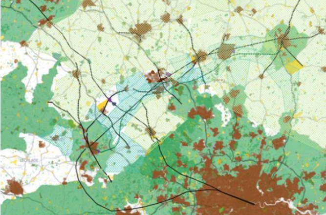
Alternative future for the CAMKOX corridor
This study aims to shed light on the characteristics of “the negotiation issue” in planning and how to deal with ne-gotiation-related complexity towards planning implementation. It conceptualizes processes of ne-gotiation that are represented/implemented via graphic and geographic elements, where the topol-ogy is a crucial factor. Our case study of the CAMKOX corridor at UCL’s geodesign workshop pro-vides new insights into the potential of digital negotiations for assessing the characteristics of plan-ning negotiation issues and their associated complexity drivers to enhance the quality of spatiality. The findings provide a detailed description of issue-based planning complexity. A shift of focus away from the products of planning to the negotiation process—as the most important considera-tion in planning—opens the possibility of implementing “shared” interventions on which there is consensus.